More than 300 days of sunshine a year and the highest altitude in France: the Hautes-Alpes combines these assets into a luminous territory that the people of Marseille know as their mountain playground. Briancon, France's highest city, guards its UNESCO-listed Vauban ramparts, while the Ecrins National Park unfurls its glaciers, turquoise lakes and trails stretching to the horizon.
Briançon: Vauban's Hilltop Fortress
The Fortified Upper Town
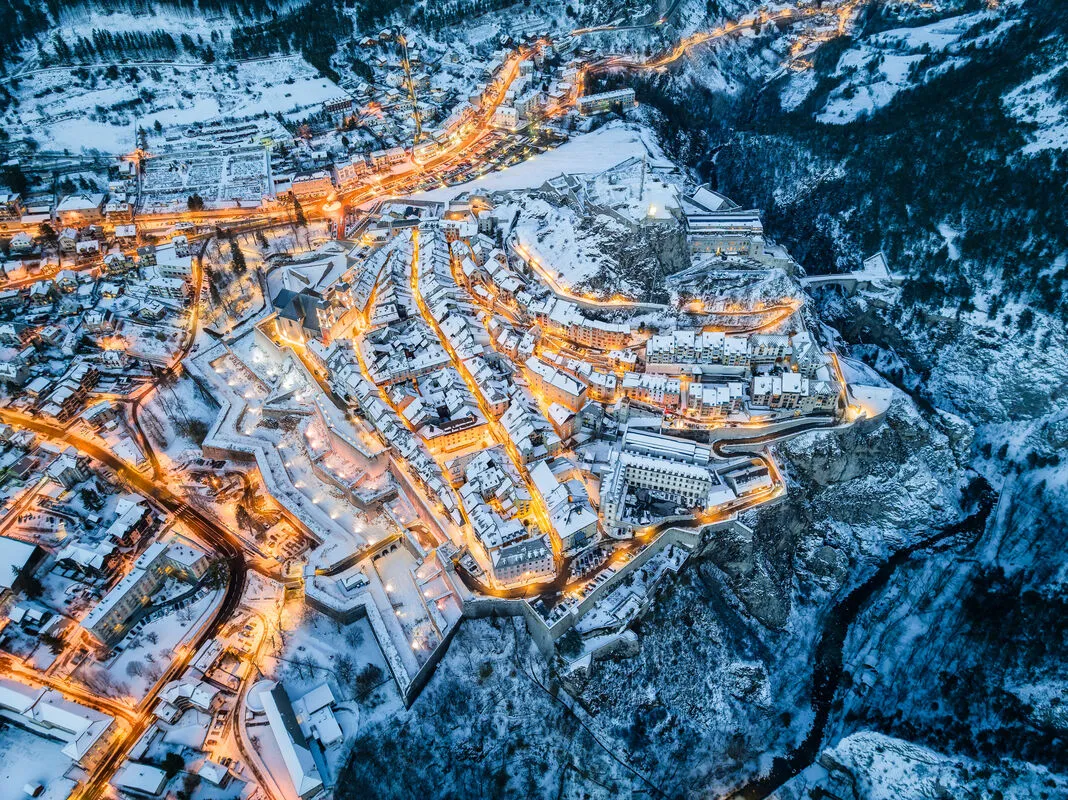
Briançon, at 1,326 meters above sea level, is the highest sub-prefecture in France and the highest city in Europe with more than 10,000 inhabitants. Its upper town, fortified by Vauban in the early eighteenth century, has been inscribed on the UNESCO World Heritage List since 2008 as part of the network of major Vauban sites. Entry is through the Porte de Pignerol, flanked by its watchtowers, or via the Pont d'Asfeld, a single-arch bridge spanning 56 meters above the Durance — a masterpiece of military engineering.
A walk through the upper town takes about 90 minutes. The narrow, steep streets, lined with colorful houses whose facades are painted with sundials, wind down in switchbacks from the Collégiale Notre-Dame-et-Saint-Nicolas to the ramparts. The Grande Gargouille, the main street with its central gutter where water cascades downhill, is the most picturesque. Themed guided tours (about 6 to 8 euros) are offered by the heritage service.
The Outer Forts
Briançon's defensive system extends far beyond the upper town. Vauban and his successors built a ring of detached forts on the surrounding peaks: the Fort des Salettes, the Fort des Trois-Têtes, the Fort du Randouillet and the Fort Dauphin. The Fort des Têtes (admission about 6 euros) is the best restored and most visitable. Its underground galleries, casemates and panoramic views over the Durance valley make for a compelling visit. The more athletic can link the forts on foot via the military trails, a loop of about 12 km with 600 meters of elevation gain.
The Écrins National Park
An Alpine Sanctuary
The Écrins National Park, created in 1973, is the largest mountain national park in metropolitan France. Its 91,800-hectare core zone harbors 150 summits above 3,000 meters, including the Barre des Écrins (4,102 m), Pelvoux (3,946 m) and La Meije (3,983 m). The glaciers, though threatened by climate change, remain spectacular, notably the Glacier Blanc, reachable from the refuge of the same name after a 3-hour hike from the Pré de Madame Carle.
Entry to the park is free. Park information centers at Vallouise, L'Argentière-la-Bessée and Châteauroux-les-Alpes provide exhibitions and hiking details (free access).
Signature Hikes
The Écrins offer walks for every level. Among the most popular:
- Lac de l'Eychauda (2,514 m), reachable in 3 hours from Monêtier-les-Bains, reveals a glacial cirque of arresting beauty
- Glacier Blanc (2,542 m at the refuge), a 3.5-hour walk from the Pré de Madame Carle, brings you face to face with the largest glacier in the massif
- Tête de la Draye (2,077 m), an easy 2.5-hour loop from Vallouise with a panoramic view over the valley
- The Tour des Écrins, a 7- to 10-day hut-to-hut trek (overnight about 40 to 55 euros in half-board), is a legendary long-distance route for experienced walkers
Refuges are open from mid-June to mid-September. Booking is strongly recommended in July and August.
Lake Serre-Ponçon
An XXL Mountain Lake
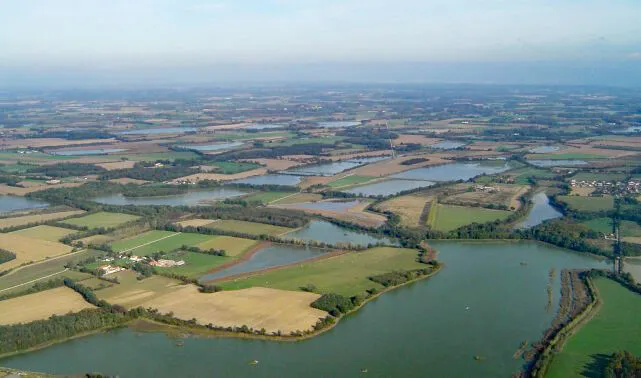
Lake Serre-Ponçon, created in 1959 by the construction of a dam on the Durance, is the largest artificial lake in metropolitan France at 28 square kilometers. Its turquoise waters, warmed by the Hautes-Alpes sunshine, reach 24 degrees Celsius in summer, making it an exceptional swimming and water-sports destination at 780 meters above sea level.
Water-sports centers around the lake offer sailing, windsurfing, kayaking, paddle boarding and water skiing (rental from 15 euros per hour). The pebble and sand beaches at Savines-le-Lac, Embrun and Chorges are free and lifeguard-patrolled in summer. The plan d'eau de Chanteloube, more sheltered, is perfect for families.
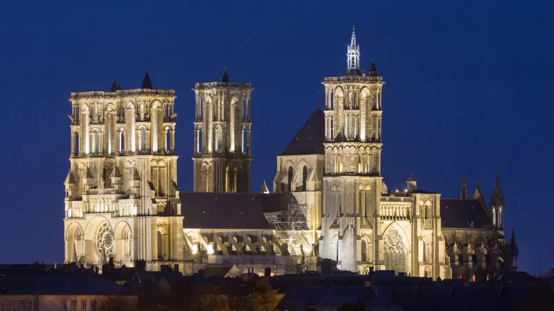
Embrun: Episcopal City
Embrun, perched on a rock overlooking the lake, is a former archiepiscopal city whose heritage merits a stop. The Cathédrale Notre-Dame-du-Réal, a twelfth-century Romanesque-Lombard building with a porch supported by pink marble columns, is an architectural gem. The Tour Brune, last remnant of the archbishops' castle, houses a small museum (admission about 3 euros). The Embrun market on Tuesday and Friday is colorful and generous.
The Queyras: An Unspoiled Valley
A Unique Alpine Heritage
The Parc naturel régional du Queyras is one of the most isolated and best-preserved territories in the French Alps. Reached by a single road from Guillestre through the spectacular Gorges du Guil, this high valley perched between 1,400 and 3,385 meters retains an exceptional pastoral heritage.
The Château Queyras (admission about 5 euros), a medieval fortress set on a glacial step at the valley entrance, watches over the gorges. Higher up, the villages of Saint-Véran (2,042 m, one of the highest permanently inhabited communes in Europe), Molines-en-Queyras and Abriès preserve traditional houses of stone and larch timber, with their fustes (stacked logs), carved wooden balconies and painted sundials.
Saint-Véran: Solar Village
Saint-Véran warrants an unhurried visit. Listed among the Most Beautiful Villages of France, this single-street settlement stretches along a sunny slope facing the Queyras peaks. The parish church shelters a gilded altarpiece and a wooden lion serving as a collection box. The Musée du Soum (admission about 4 euros) recreates the traditional habitat and way of life in the Queyras. The houses, with their lower stone sections (for animals and storage) and upper larch-wood sections (for living quarters and hay drying), illustrate a remarkable adaptation to life at altitude.
Gap: Luminous Prefecture
Gap, prefecture of the Hautes-Alpes at 735 meters above sea level, is a pleasant town ringed by mountains. Its historic center can be walked in an hour, taking in the cathedral, shaded squares and pedestrian streets lined with shops. The Saturday market, heavily attended, is one of the largest in southeastern France, with local producers selling mountain cheeses, honey, walnuts, cured meats and tourtons (stuffed fritters typical of the Hautes-Alpes, about 2 to 3 euros each). Gap makes an excellent base for exploring the département.
Summer and Winter Activities
Summer
The Hautes-Alpes is a summer paradise: hiking in the Écrins and Queyras, mountain biking at Serre Chevalier and Orcières resorts, via ferrata at La Grave and Freissinières, rafting and canyoning on the Durance and Guil (from 35 euros per descent), paragliding above Lake Serre-Ponçon (tandem flight about 80 to 110 euros).
Winter
In winter, the département offers a vast and varied ski area: Serre Chevalier (250 km of slopes, day pass about 48 to 55 euros), Montgenèvre (a Franco-Italian resort in the international Milky Way domain), Vars-Risoul (the Forêt Blanche domain), and family-friendly stations such as Orcières-Merlette and Réallon. Cross-country skiing and snowshoeing are excellent in the Queyras and the Clarée valley.
Practical Tips
- When to go: June to September for hiking and the lake, December to April for skiing, year-round for Briançon
- Getting around: A car is essential. Gap is 3 hours from Marseille and 2.5 hours from Grenoble. Regional trains serve Gap and Briançon from Marseille and Valence TGV
- Accommodation budget: Expect 60 to 130 euros per night in a hotel or chambre d'hôtes, 40 to 55 euros in a mountain refuge (half-board)
- How long: 5 to 8 days for a full tour. 1 to 2 days for Briançon, 2 days for the Écrins, 1 day for Serre-Ponçon, 1 to 2 days for the Queyras
- Do not miss: The upper town of Briançon at sunset, the hike to the Glacier Blanc, a swim in Lake Serre-Ponçon, and the village of Saint-Véran in the early morning
Explore on the map
Map →📚 Related collections
Related guides
 Regions
Ain: Bresse, Dombes and Pays de Gex
Discover the Ain: world-famous Bresse poultry, the thousand ponds of the Dombes, Pays de Gex facing Mont Blanc and the emerald gorges of Nantua. Complete guide.
 Regions
Aisne: Laon's Medieval Citadel and the Chemin des Dames
Discover the Aisne département: Laon's hilltop medieval city, the Chemin des Dames battlefields, Soissons, the Familistère de Guise and Champagne vineyards. Complete travel guide.